Programs used;
1- SQL Server 2008R2 Express
2- SQL Server Management Studio 2008R2 Express
3- QGIS
The example uses UK national grids coordinates to create a Triangle Polygon in a SQL Server Table
I’ve previously written that while we’ve had spatially enabled SQL Server for over 5 years I constantly come across line of business applications that although using SQL Server have not and do not intend to spatially enable the application. This is undoubtedly because of the difficulty in re-designing legacy systems actively in use and because the benefits although significant are not generally requested by all but the most knowledgable of colleagues.
While I understand this legacy system reasoning spatially enabled databases are the future so its just a matter of when and not if an application will require alteration. Understanding it in this context makes it really a requirement to start seriously planning for its inclusion.
Developerers creating new applications however should always consider spatially enabling relevant tables from the start even if it is not specked by the client/colleague. It being so much easier to spend a couple of minutes future proofing the schema of a new born database rather than hours trying to retrofit a live in production back end.
Firstly it’s important to understand what a geodatabase in SQL Server actually is.
Really it is a normal database which has one table that has a field that has a geometry or geography value type. In this example I will use desktop QGIS 2.8.1 to display the resulting geometry but any other digital mapping package that can link to SQL Server could be used. SQL Server also has a very rudimentary Mapping Display but you will need something better if you want to manipulate boundaries visually.
Many digital mapping products have plugins that will create Geodatabases and tables however I haven’t seen one for QGIS. I really wanted to be able to create spatial SQL tables on my own without recourse to paid tools directly in SQL Server Management Studio. So here’s my method of creating blank polygon table whose geometry is ready to be read and edited in QGIS or any other digital mapping system just using SQL Server Management Studio Express 08R2.
Steps
1. Create a new Table
2. Ensure the table has an identity Key that increments
3. Create a geometry column
4. Write a query that updates the geometry column
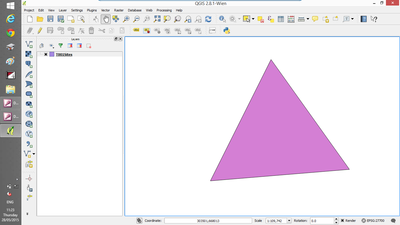
UPDATE T001Sites SET Coordinates=geometry::STGeomFromText(‘POLYGON((301804 675762,295789 663732,309581 664870,301804 675762))’,27700)
You will note that there are four coordinates here (each coordinate being a pair of numbers )
The first coordinate and last are the same this is required by SQL to ensure that the polygon is closed.
The 27700 number is the Spatial Reference System Identifier (SRID) – it is a unique value used to unambiguosly identify projecttion. 27700 is the unique identifier for the United Kingdom National Grid and represents the coordinates my example refer to. The spatial reference identification system is defined by the European Petroleum Survey Group (EPSG) standard which is a set of standards developmed for cartography surveying etc and owned by the Oil and Gas Producers Group list here; http://www.epsg-registry.org/
The above coordinates display a triangle in West Lothian near Edinburgh
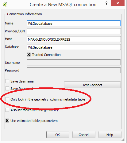
5. Set up the connection to SQL Server Instance
Ensure the box marked “Only look in the geometry_columns metadata table” checkbox is unchecked. By default this is checked and if the geometry_columns table does not exist you will get an error message.
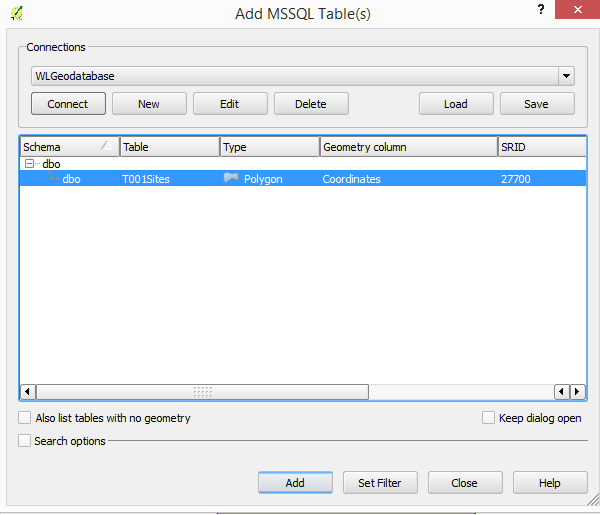
6. Display the table and edit as appropriate.
Select the table then hit the Add button
And here is the SQL Server table in QGIS ready to be added to or edited.